New guidelines were announced February 2007 which requires that for federal funding, projects:
See the guidelines and the underlying federal law. The prior guidelines mandated "highest and best transit use". FTA still cannot reject a project simply because it does not preserve greenspace.
Approved Board Action/Information Summary: (3Mb PDF) "Purpose: To obtain Board of Directors approval of the 1) Final public hearing staff report for Takoma Station; 2) Amendment of the Takoma Station General Plans to include bus facilities and parking and access changes, including a 121-space garage; 3) Amendment of the Adopted Regional System plan for the Takoma Station to include the above changes; and 4) First Amendment to the Purchase, Sale, and Development Agreement." This package for the WMATA board offers no hint that there is disagreement with going ahead with this. WMA Audio recording of October meeting where the board did not know without a legal opinion whether they had the votes or not. WMA Audio recording of November meeting where abstentions were declared not allowed.
The August 2007 Staff Report (300KB pdf) and its exhibits (7MB pdf), with the site plan (1MB) also available separately. Note how on page 25, 50 parking spaces were added to the existing lot mysteriously without WMATA's authorization. Therefore the existing lot actually only should count as 100 spaces, not the 149 that are there. There is a lot more creative bookkeeping on that page as well. The responses to the report are sorted by last name: A-D (400KB pdf), E-K (650KB pdf), L-O (250KB pdf), P (20MB pdf), R-Z (6MB pdf) and Postcards (17MB pdf).
A transcript of the hearing (300KB pdf) as well as a 3 hour video of the 11 October 2006 compact hearing, posted in Windows Media format. The written testimony is a 41Mb, 765 page pdf sorted by last name containing many other documents that were submitted.
Many individuals and officials written statements are archived on a Yahoo Group archive.
In preparation for the 11 Oct. 2006 public hearing ("compact hearing") at Trinity Episcopal, 7005 Piney Branch Rd NW DC, WMATA released a package of documents. All are PDFs unless noted. Many external documents are scanned versions of documents that exist in other forms, see below.
1 - Notice of the Public Hearing (116KB)
2 - Plan of Property Showing Existing Conditions (45KB
single line drawing)
3 - Proposed Development Plan (8MB, includes drawings of
latest proposal options with and without 2 level garage)
4 -
WMATA Compact (link to section of WMATA website)
5 - Sales and Contract Dated June 20, 2005 (8MB)
6 - Regional Bus Study - September 2003
: part 1 (19MB, Final Operating Plan additional Ride On
routes needed.) and
part 2 (4MB Final Report summarizes part 1)
7 - Phase I Environmental Study (6 MB, includes interesting
historical details and maps of the site)
8 - Phase II Environmental Study (2MB Soil and groundwater
chemical analysis)
9 - WMATA Environmental Evaluation (18MB,
my uncomplimentary opinion of this document is here)
10 - Wells Traffic Study (1MB, Commissioned by EYA, it
cites the Takoma Transportation Study and states, without any
analysis, that the development will add 16 AM rush hour trips.
That, to me, means that if townhouses of this size have two
adults, then only 4% of adults in a development with 2 car
garages will commute by car. This is a figure that I would like
to see justification for.)
11 - Central District Plan (5 MB, Download is broken into
chapters and is in color on the
DC Office of Planning website)
12 - Takoma Transportation Study (39MB, Since the meat of
this study is in tables presented in landscape and their OCR
did not work on them, I suggest going to the DC
DOT website. Also, the WMATA version is black and white and
many parts of the report are color coded. The most relevant
portion can be found at
All Issues and Recommendations Map - Area 1.)
13 - Planning Study Report (4MB, Final report of March 4
2006 meeting where many problems were found with EYA's
proposal and many alternatives were enumerated. The reports
list, but does not evaluate these.)
14 - Prior WMATA Board Minutes Re: Takoma (5Mb, A part of
the record on the back and forth by the WMATA board on the
number of parking spaces needed when the station was first
planned)
WMATA November 9, 2005 Town Hall Meeting transcript (269KB, in which Takoma was mentioned)
WMATA Request for FTA Approval, 15 July 2005
There are some tables as attachments that did not come out well. They seem to be a standard FTA form (in a smaller font) and WMATA's response in a larger font. "See Attachment", refers to the following page
Note what WMATA did not submit. They did not submit the Site Plan or The Takoma Transportation Plan. Also, we learn that WMATA is counting the street/guest parking in front of the townhouses as a substitute for the missing parking lot spaces.
Takoma Park MD resolution to the FTA of 18 July 2005
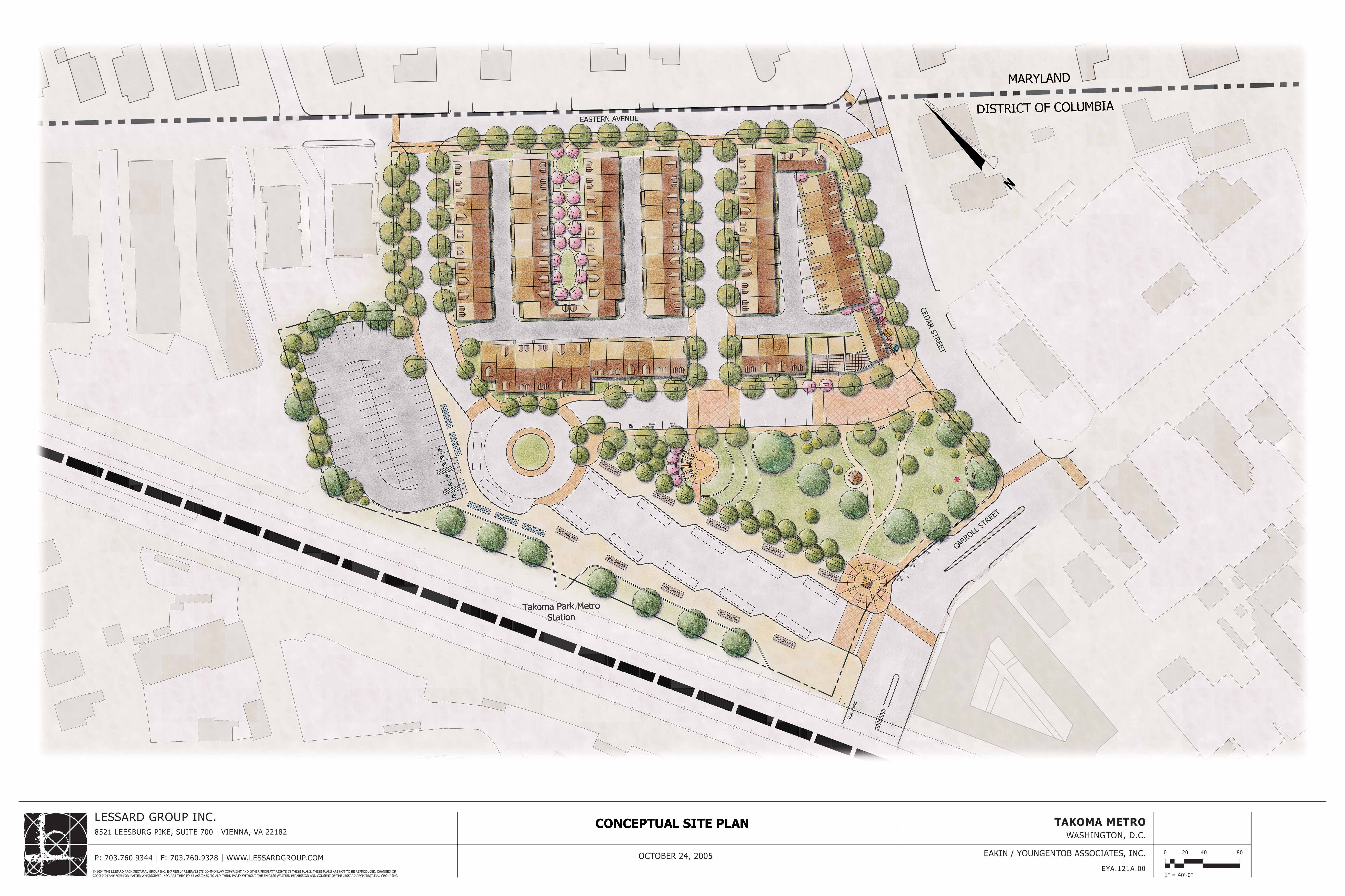
EYA site drawing of 24 October 2005 (1 Mb)
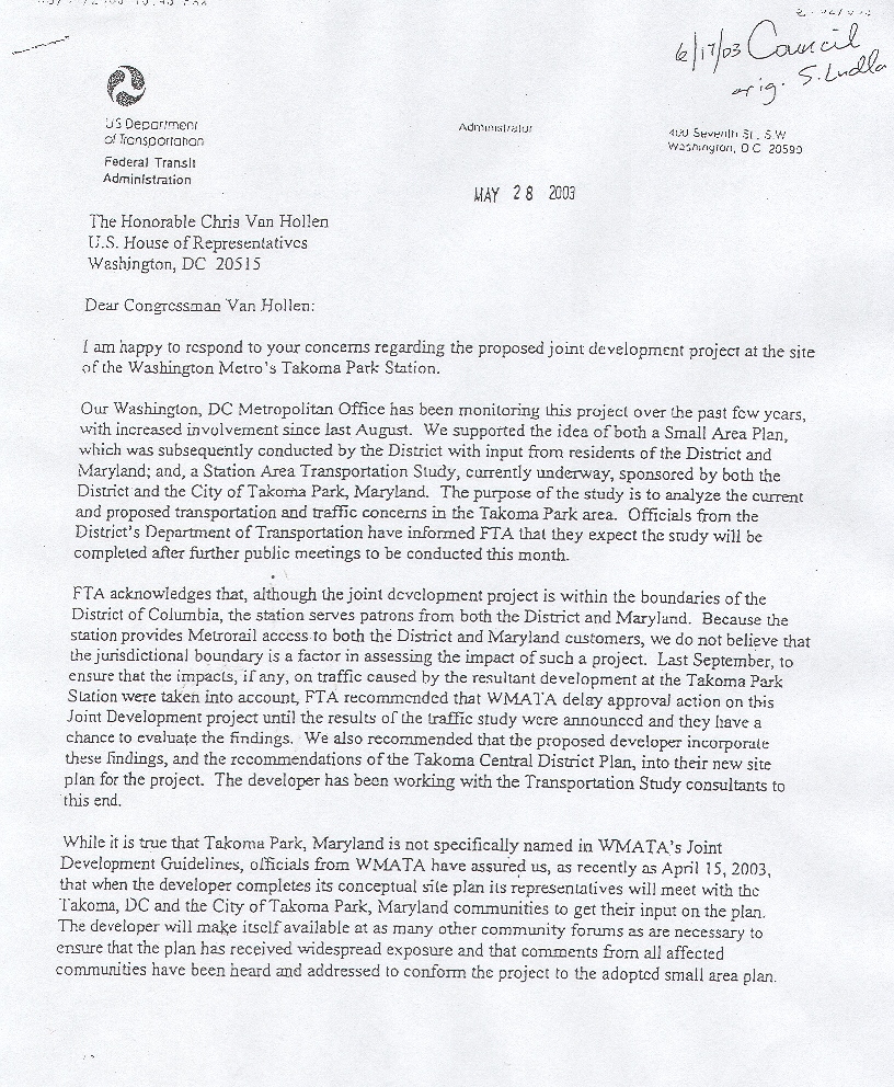
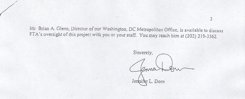
This letter states that FTA recommended that EYA incorporate the findings from the "Currently Underway" transportation study in the development project. Click for gif of Page 1 (600 KB) and Page 2 (160 KB).
Faith Wheeler's July 2005 table of housing projects (80KB pdf) within a 4 block area of the Takoma station shows 346 new housing units in the approval process, 41 more than the transportation plan projected by the year 2012. This does not include the 95 units on the WMATA property, or 215-345 units other units expected to be built in the area.
These concepts are in response to Jim Graham's invitation to the community to submit a proposal around which the community could unite. They are also contained in the WMATA Report of that meeting.
Seekers Church
276 Carroll St NW
Washington DC 20012
http://www.SeekersChurch.org
WriteSeekers@SeekersChurch.org
Board of Directors
Washington Metropolitan Area Transit Authority
600 Fifth Street NW
Washington, DC 20001
Re: Hearing No. 175 / Docket No. R06-5
Dear Chairwoman Mack and Board Members,
I represent Seekers Church, a DC church located across Carroll St. from the Takoma station. We walk, bike and take the subway to church. We consider the station site to be a gateway between DC and MD, and the center of an integrated Takoma community.
The Takoma Central District Plan is the product of a community-driven planning process, which was unanimously ratified by the DC Council. It incorporates by reference the Takoma Transportation Study, conducted by both DC and Takoma Park MD.
It is imperative that redevelopment comply with these recommendations. This means that:
1. The site must provide adequate parking to allow Takoma non-commuters, who are unable to walk to the station, to use the rail system for shopping and other short-term excursions. DC regulations allow townhouse residents to declare street parking in front of their homes as by permit only. Resident permit-only street parking does not meet this demand.
2. The housing must invite rail commuters to move there by limiting private parking to one space per unit. WMATA won't benefit if two-car commuters move there, as EYA promotes.
3. There must be "50 new bike racks accommodate increased demand due to the implementation of the Metropolitan Branch Trail." We suggest that a video camera cover those racks to discourage theft and vandalism.
4. We must create an "accessible entrance from the west to the station by extending the tunnel used for ADA access on the eastern side." This improves the site as a gateway, instead of a barrier, between DC and MD, especially for DC bike/ride commuters and the DC Wheelchair bound. Since the western branch of the Metropolitan Trail will run down Spring Place, we must link the bike network with the bicycle entrance. Moreover, Gables Residential is building 144 rental units having only 185 parking spaces on Spring Pl with more developments planned to turn junkyards into a subway ridership community.
5. Appendix H of the Transportation Study (which was omitted from this meeting's information package, but which I am attaching here) demonstrates the need for 11 actively used bus bays plus a spare. EYA only grants 10.
6. The station must protect a covenant with its neighbors made when it was first planned that a buffer would separate homes from diesel traffic. EYA does not provide it.
In summary, these EYA alternatives must be redrafted, or re-bid if necessary, to comply with the Central District Plan and Transportation Study.
Thank You.
Jeffrey P. Silverstone
Seekers Church
Board of Directors
Washington Metropolitan Area Transit Authority
600 Fifth Street NW
Washington, DC 20001
Re: Hearing No. 175 / Docket No. R06-5
Dear Chairwoman Mack and Board Members,
I sent in an earlier statement on behalf of Seekers Church. Unlike that statement, this supplementary statement represents my own views not those of the Church.
I was delighted to see that the compact hearing was so well attended and the video of it is available for view at http://takomapark.granicus.com/ASX.php?clip_id=134 . By my count, of the 14 individuals and organizations who identified themselves as living or working in Takoma DC, 11 were against both EYA alternatives, 2 were for the garage alternative only and 1 expressed no opinion other than any construction should use green materials. This shows that Takoma DC resoundingly opposes this EYA attempt at Smart Growth.
I am offering this statement because I just saw the environmental evaluation published on your website. I had not seen it before because it was added to the website later than the other documents. It is quite clear that this was a hastily done document that was rushed to completion before the hearing. As a result, it contains many inaccuracies and no one should treat it as authoritative in any evaluation of the EYA alternatives.
The table on page 8 is fascinating. It is an attempt to show that the parking under the alternative plan is the same as what exists now. To do that, it counts 29 spaces as within project street parking and 12 spaces along Cedar St. into the mix. I do not want to dwell on the fact that DC regulations provide that the 29 spaces be made available for residents only parking. Instead, I want to examine the supposition that the EYA alternative will make 12 new spaces available on Cedar St. In fact, the math is wrong. 12 fewer spaces will be made available on Cedar St.
The document supposes that there is no parking along that street right now. If you go there, you will see about 12 parking meters all lined up to provide parking for non-commuters. This is in addition to the Taxicab stand, which, in fact, is used as an overflow bus layover spot.
The document further supposes that 12 spaces will be available in the future. In fact, the eastern branch of the Metropolitan Branch Trail is scheduled to take that lane for use of the bike trail. I am sure that this mistake was just a slipup, but it should be corrected.
This same table supposes that the number of bus layover spaces increase from zero to two. In fact, the number will decrease from the three spaces that are used now for layover to two. If you observe the buses at the station, you will typically see one bus standing on the north side of the existing bus turnabout, one bus waiting across from the turnabout near the parking lot and one waiting across from the 7-11 in the otherwise unused taxicab spaces. Again, I am sure that this mistake was just a slipup, but it should be corrected.
The table also supposes that the EYA proposal has 38 bike racks and 60 bike lockers, which is exactly the present number. I suspect that when the table was drawn up they got the existing number confused with the proposed number. There is nothing in the supporting drawings to suggest that EYA is proposing any bike racks nor more than 40 bike lockers. I suspect that the EYA cut was so drastic that the author of the table got confused, but either the table should be corrected, or the EYA drawings need to suggest where they are putting these bike racks and lockers.
Section 4.10 suggests, “There are no parklands on the current site.” Merriam-Webster (at http://www.m-w.com/dictionary/parkland ) defines parkland as “land with clumps of trees and shrubs in cultivated condition used as or suitable for use as a park.” Note that it does not say that the land has to be designated as a park, just suitable for use as a park. This describes the existing “green area” perfectly. By including this supposition, the “environmental evaluation” does not even need to examine the environmental impact of cutting down dozens of mature trees, paving over acres of grass and rerouting underground streams. I think perhaps, the pocket green proposed can be described as too small to be parkland. Once again, there was a mistake that is understandable given the haste to get this document out, but it needs to be corrected and an honest environmental assessment needs to be conducted.
Thank You.
Jeffrey P. Silverstone